I took some time off from work. J had time off as well. We made a "plan A", to camp out deep in the wilderness at the "Uphill" lean-to near Mount Marcy. It would be significantly colder and windier there than anywhere else, but the advantage is that we'd have easy access to several tough peaks. As the time drew closer, the temperature dropped from 30's and 20's down to 0's, with predictions at Lake Placid going as low as -26 degrees not including a wind chill! Time for a plan B.
The Seward range in the Adirondacks is a group of 4 remote mountains in the far northwest portion of the High Peaks region. The trails to the peaks are unmarked and the peaks are much less traveled than many of the more popular ones so even in summer you can really get away from it all. Fires are allowed, making it an ideal spot for our 3-day chilly weather camping expedition. It would be zeroish for our first day and night, and a few degrees warmer for our big day of hiking, followed by a chillier day as we make our exit. We'll carry our packs to one of the lean-to's and hike Seymour on the first day. The second day we'll travel light and hike the other 3 peaks, two of them twice for the return trip. Finally, on the last day we will wake up early and make a quick exit.
We made a plan to meet at 6am with the expectation that we would run late, expecting to start driving at 7. I think we made it out at more like 8:30 or so, which was awesome because that's the exact time Sorrentino's Deli opens up in Clifton Park! We stopped for subs, Chex Mix, and breakfast sandwiches along the nearly 3 hour drive to the trailhead. It must have been around noon when we pulled into the parking area. One other car was there: another late starter whose name is B. We chatted with B a bit as we got our stuff together. His plan was to hike the area solo and visit Duck Hole, and possibly the Santanonis for 4 nights! I mentioned that it was going to be cold, and he was aware and had two sleeping bags and a tower of sleeping pads to help him combat the conditions.
During the hike to the lean-to, several barely frozen brooks gurgled under our feet as we big booted across, trying to walk on lumps (rocks) instead of flat stuff (thin ice) as much as possible. We managed to stay dry for the 3.8 mile walk.
We quickly got our day-hiking gear together for the hike up Seymour: snacks, water, and microspikes. Oh, yeah, and headlamps, don't forget those because it's almost dark already!
There wasn't more than an inch or so of snow on the hike to the lean-to. However, within a few hundred feet of hiking towards our destination, we found ourselves walking through deeper snow with 4 or 5 inches making it a little tougher to walk. We turned back and fetched our snowshoes, just in case.
Before long we turned on our headlamps. The 5 mile out-and-back hike sounded very easy. Until we started hiking of course. We always forget just how long it takes to hike up mountains in the snow, especially when the first mile or so goes by quickly. Before long the trail gets steep and each step is a carefully calculated double stomp into the icy crust to gain traction. Hours were ticking by as we worked our way to the summit. I was constantly adjusting the my gloves and hat, trying to keep my hands, nose, and face from freezing. A full moon struggled to penetrate the thick of clouds above us, doing little to light our way to the peak. Once there, we gave a brief rejoice, and hurried our way down and back to the lean-to. The descent went quickly until we hit the flats at which point it felt like we should be there already, but we still had a long hike before reaching home.
B was back at the lean-to to give us company on this cold night. We quickly put on warm clothes and started fetching firewood. B had carried in some nice kindling and started the fire. We gathered a lot of great wood, but it took us an hour or two to really get the fire going. The fire consumed fuel as fast as we could collect it, but we were determined and kept it going for the night while we ate steak and frozen subs before packing it in for the night.
We slept in and got up to get ready for a big day of hiking. I fetched water and went to boil it, but alas, my finicky stove (which I had very recently tried to fix and clean) refused to work. So I woke up J and set him to work boiling water for a quick oatmeal breakfast.
We hit the trail around 10:30am, this time without snowshoes. According to National Geographic mapping software that I use the total distance for today's hike should be around 8 miles (four out and four back), although it has been known to underestimate at times. We discussed that once we hit 2.5 miles we were in good shape, because after that the last 1.5 miles to the 3rd peak shouldn't be too bad! We hit 2.4 miles according to the GPS watch and patted ourselves on the back for a job well done and pressed on. After a long period of hiking I checked our distance. I turned to J and told him, "we're at 2.6 miles now". He replied, "That's not possible". We shrugged it off and continued.
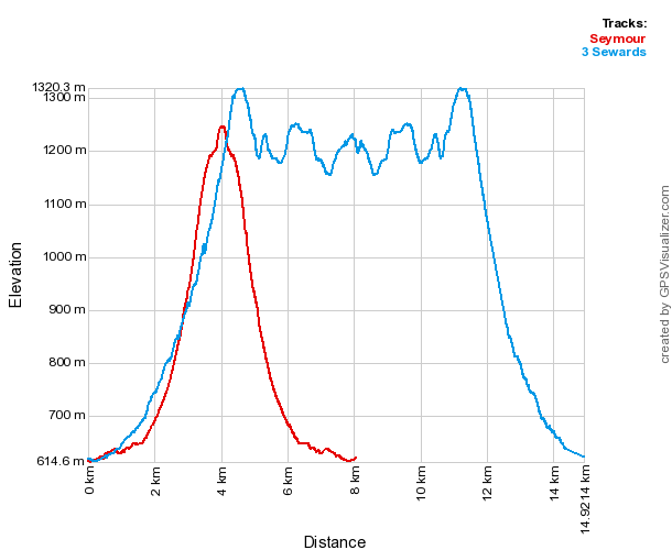
For some inexplicable reason this hike is always much more difficult than the hike up Seymour. It's happened to me twice, and I've heard similar comments from other hikers. It's easy to look at the map and get the impression that Seymour (which we did the day before) and Seward are similar hikes. Comparing the two elevation profiles does little to reveal why one is so much more difficult than the other:
Every trip has to have a special moment or it wouldn't be an adventure, right? Shortly after putting on microspikes while descending Seward towards Donaldson, we come across the scary part of our trip. The trail becomes a super-steep 50-foot long cascade of the worst kind of glistening ice with no "easy way" around it. We warn each other to stop. And to not die. Thoughts of turning back come and go, but we decide to give it a shot. There are roots and trees to hold onto for most of the way, and as soon as we step onto the ice our spikes sink right in. Luckily the ice is softer than it looks enabling us to make it down safely, with only one really sketchy part halfway down where you have to cross from the left side of the trail to the right without any handholds. We breathe a big sigh of relief and bump fists after making it down. However, this sets a mood for the rest of the trip. At this point, getting hurt is not allowed. It's going to be tough getting back up it in the dark if we're feeling 100%. And it's hard to imagine even a well trained rescue team being able get someone back up that precarious drop.
It feels like a very long way before we reach Donaldson. I take a quick look at the map and (wrongly) tell J, "the hike from Donaldson to Emmons is going to be a cakewalk". It looks like a flat ridgeline, mostly descending to Emmons. The hike to Emmons is anything but a cakewalk. The trail is long and not well travelled so the snow is deeper making for slow going, and the trail is nearly impossible to see, even moreso because the trees are thin so every direction looks like a trail.
We spend a lot of time probing for the trail. Eventually we get to where it's obvious we are standing mere footsteps from the peak, yet the trail phases in and out of existence like a haunting spectre. Night has fallen and our headlamps can't work miracles. I am starting to lose it a little. I was foolishly expecting a short, easy hike on an obvious trail with no snow, none of which are true. Admittedly, I'm tired and hopelessness settles in as we thrash around the wilderness winding every which way except the right way. J is holding it together much better than I, and miraculously crashes through some woods and announces, "here's the trail", and we climb to the top. Woot!
The return trip should be easy because we can follow our own tracks. Except for the sections where we sabotaged ourselves by scribbling tracks all over the place. As I said, I'm getting tired and losing it a little. I'm in marching forward in Lalaland, largely oblivious to the icy drop to my left. My spikes lose purchase and I tumble down 10 feet or so, crashing into bushes at the bottom. I stand up a little shaken. J starts to follow and I tell him, "that was not intentional, straight is probably easier."
There is a claustrophobic feeling caused by the icy wall we still need to climb in the dark. We are boxed in by it. It is a great relief to finally reach it and arrive at the top unscathed. From there it is a quick climb to the top of Seward and then the final descent to the lean-to.
We drop down the side of the mountain. Now we notice how incredibly steep this section of trail is. Each small step becomes a giant leap due to the near vertical decline. J points out that this is the section that took forever to go from 2.4 miles to 2.6 miles. The funny thing is, it didn't seem particularly steep on the way up. Just slow.
We cruise merrily back into our campsite at around 8:30. We forego a fire, and cook up some easy food, hang out for a bit, and go to bed. In the morning we wake super early, pack up and hike out, eating a light snack along the way.
We stopped at Druthers in Saratoga for a big lunch. I was the lucky one, my lunch stayed in my belly.
All in all another great trip.
Nice report. Are you going
Nice report. Are you going for all the peaks in winter? Good to knock out those ones. On our day trip attempt at a winter ascent of S,E,+D (from the far parking lot) we omitted Seward, still took about 9 hrs. Wound up doing Seymour 45 + seward 46 camping at the 1st lento 2 nights a couple years later. 12 yrs ago!! OK just watched the video. YAK TRAX!!
I'm keeping track of the
I'm keeping track of the winter peaks and when we go out I definitely lean towards knocking some good ones off the list. So I'm not necessarily going for all the peaks but it is heading in that direction. This trip puts me at 21 winter peaks. I gotta say going out there makes me realize how tough every hike is. It is humbling and gives me a lot of respect for anyone that hikes just a few peaks in winter, never mind all 46!