Trip Report
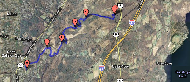
I kayaked 5 miles of the Kayaderosseras today (click on the following map for an interactive version):

I started at the boat launch area in Ballston Spa. I paddled along at a relaxed but steady pace. I covered the roughly 5 miles of river in 1 hour, 12 minutes. The water level was very high. When I have canoed this route in the past, log jams meant that I had to get out and pull the canoe over to get through. This time, the water level was high enough (and the kayak nimble enough) that I was able to get through all of the log jams without getting out of the kayak.
The entire trip including packing up, driving, kayaking, biking, and unpacking took roughly 3 hours (although I had somewhere to be, so I was hurrying along).
At one point there is a small waterfall with lots of fast moving water rushing down it. It was easy to get down, and I tried to paddle back up it just to see what would happen. As I got into the thick of things, the kayak spun around and on the way I very nearly flipped over. It looks like I have a couple of things to learn, like how to unflip when I flip over. The real trick will be to keep my $8 glasses on my head as I do so. I saw a very large turtle swimming, some nice birds, lots of ducks. I'd like to explore more of the river later. A little further upstream, it looks as though there might be some faster moving water.
Kayak/Bike Method
At this time, my personal preference is to go exclusively downstream. My usual method for making that happen is to park and start paddling the kayak downstream with a padlock and my running shoes. I paddle until I find a good stopping point at which point I lock up the kayak, and run back to the car. Then I drive to pick up the kayak and head home. It's a perfect system because I don't need to plan how far I'm going to go, and there isn't much driving back-and-forth. It's almost as good as calling mom for a ride home when you get tired. However, my foot is injured so I can't run right now so I needed to come up with another plan. If I had a friend, then we might use the two-car method. But I don't have a friend. I recently managed to cram the entire kayak into my Civic and close all the doors. This allows me to attach a bike rack and bring a bicycle along. The new system is to lock up the bike at my destination, drive to the starting point, kayak to the destination, lock up the kayak, bike to the car, drive to the kayak, pack up, and head home. It's a few more steps, and a little more driving, but it works and it means I don't have to paddle upstream (which means I get to cover a lot of water).
Special Fishing Regulations
This section of the creek has some unusual fishing restrictions. It is closed for fishing during certain parts of the year, I believe because the monster fish (Walleye, etc.) in Saratoga Lake spawn here. Also, upstream from here, trout fishing is legal all-year-round. As of 2011, the regulations are as follows (taken from the NYSDEC Special Regulations for Saratoga County):
Kayaderosseras Creek from Saratoga Lake upstream to first railroad bridge: Fishing prohibited March 16 until the opening of walleye season in May.
Interesting Links
* Kayak/Canoe Launch Sites on the Kayaderosseras
* A map of the same launch sites
* Friends of the Kayadersseras - Help clean up the creek.
* How to pronounce Kayaderosseras (and other local names)
Related Entries
* Kayaderosseras Rapids - 30 June 2011
* Kayaked the Mourning Kill - 26 June 2011
