
|
Main /
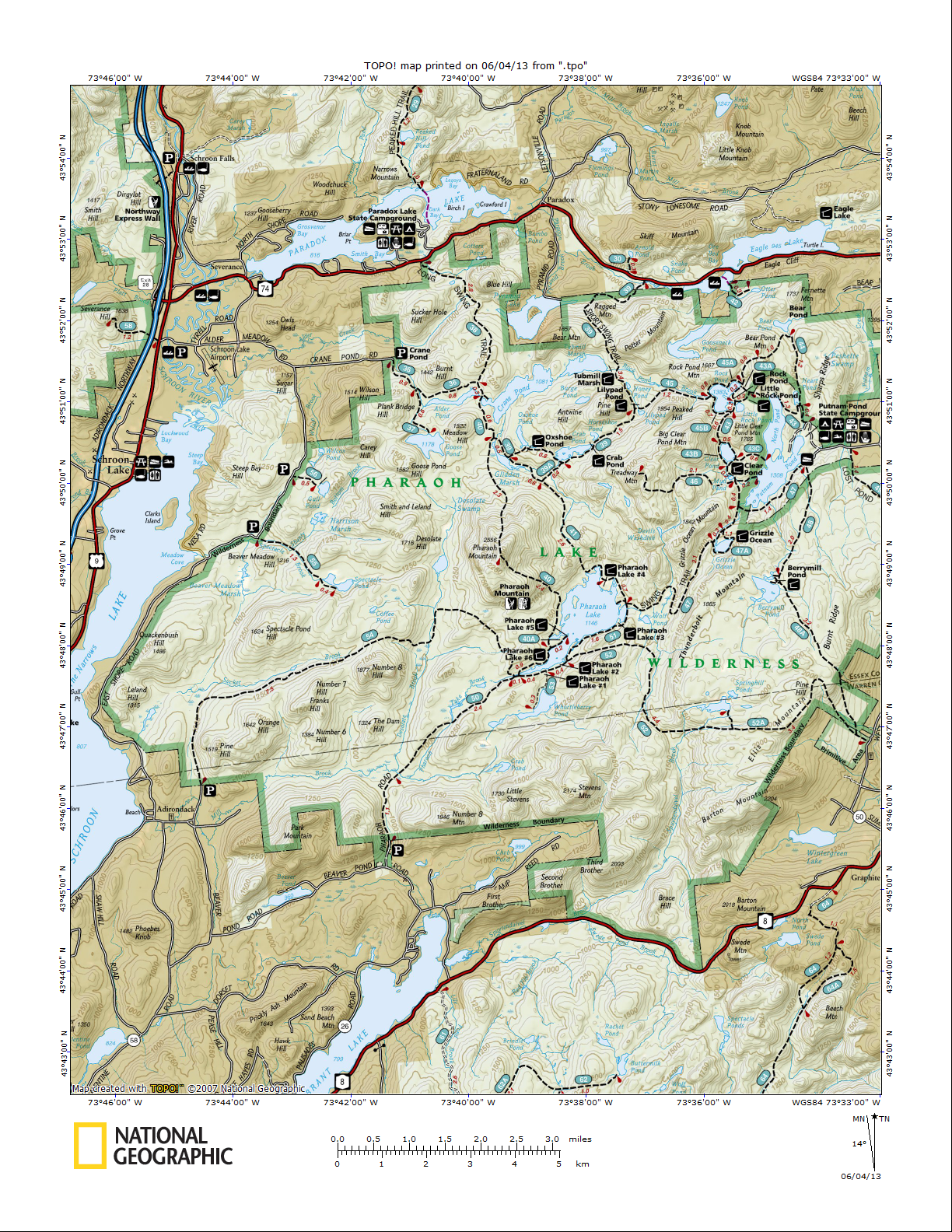
PharoahLakeTrails21.5m Route w/7500' total elevation change, starting in SE corner 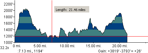 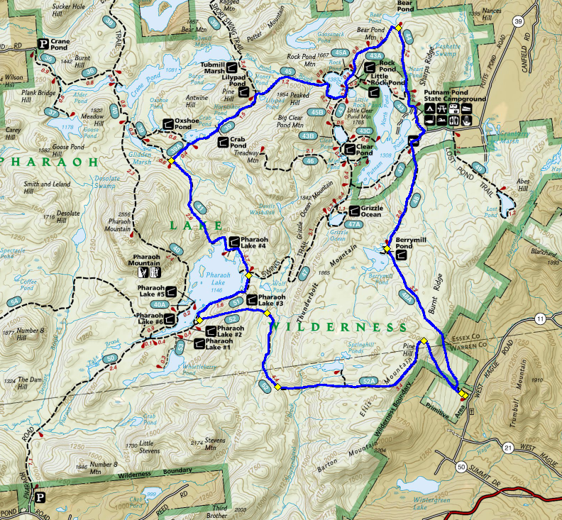 First 0.3 miles: Springhill Ponds from the South - The start of this trail is from a small parking area off West Hague Road. The trail starts out following yellow markers and then reaches a fork at 0.3 miles. At the fork is the junction of the Springhill Ponds from the South Trail, which goes left. This is our trail. Mile 0.3-3 (52A): Heads towards Springhill Ponds To Pharaoh Lake (52): Red marked trail. Takes us to Pharoah Lake Trail. Wet, poorly marked, not well maintained, tough to follow at times Along East Shore of Pharoah Lake (51) Nice views of lake & mountains. Pass a lean-to, stay left when the swing trail heads to the right, Gidden Marsh Trail (or Long Swing Trail according to DEC signs) (41) Marked yellow. Tubmill Marsh Trail (or Short Swing Trail) (39) Look for a right turn onto Lilypad Pond Trail heading east, marked red. If you’re heading north you’ve missed the turn! Lilypad Pond Trail (or Rock Pond to Lilypad Pond Trail) (45) Red marked trail. Takes us to Rock Pond. Perhaps stay left around the pond, then left again for the Bear Pond Trail (43A). Bear Pond Trail (44) At 1.0 miles, blueberry bushes! Crosses over Bear Pond Mountain then heads south. Stay straight (past trail on right back to Rock Pond, dirt road or something on right), then take right on road at Putnam Pond State Campground. Then left onto blue marked trail near exit of the parking area in campground. Berrymill Flow from the North (48) Blue marked trail. Maps call this Berrymill Pond, but signs on the trail call it Berrymill Flow. Take left at final junction onto yellow-marked trail back to the car. Trip report, 7/5/13: We started off on the wrong foot by parking at the wrong spot and heading down the wrong trail. There was a parking area and a trail a few hundred yards south of the actual parking area. (** Note: There is a very official DEC trailhead and parking area: start there! **). We ended up wandering nonsensically through misc trails for 4 miles before returning to where we started to find the real trail head. The run from West Hague Road to Pharoah Lake was absolutely treacherous. It was a mucky swampy mess. The trail is marked but we could never get going for more than a short bit before we had to navigate repeated giant mush holes. Ugh. Partway through, my morale severely crippled, I hit my low point. I started shreiking and running in hopes that a forced berzerker rage would pull me out of my funk. It half worked, which was good enough to keep me moving forward. As we say in the business, "your biggest enemy is hope". Lucky for us we had absolutely no hope at this point, so reaching our first waypoint, Pharoah Lake, came as an unexpected happy surprise. This section of trial is one that as of right now (two days later) I hope to never see again. We headed towards a lean-to on the lake. Friendly people were staying there who had hauled a boat or two for several miles to the campground. We greeted each other and they took a look at us covered in Hell and seriously asked us if we swam here. We explained our story, and they explained their's (dragging a giant boat 4 miles uphill over 8 hours). No strangers to a hard day's work, they offered us a dive into the refreshing water below. After wasting 4 miles and dealing with a really tough 7 or so after that, we had a great swim and snack by the lake. We had several options at this point, all of them terrible. We were obviously not going to stick with the plan, which would mean another 15 miles for a total of 26. The easiest option would be to run back from whence we came (as terrible as it was) for a total of 18 or so miles. The remaining option would be to take a diagonal shortcut through Grizzle Ocean, for a total of 22 miles back to the car. We had no reason to believe that this trail would be any friendlier than the last, but at least it would be different. There was some hesitance to take on the long route, but a campground 6 miles in left an option to bail-out if need-be, which sealed the deal and put us all in agreement. We hopped back on the trail and honestly at this point I don't remember much besides running, getting chased by angry dogs, H making an aggressive hail mary run for the campground, B bonking, and me losing a sandal deep DEEP in the mud and probing for it with a black arm for several minutes. At the campground, H chose to hang back while B and I ran the last 5 mile section. Oh man was it sweet! We got on the trial and ran! Yeah! Then it got even better, the trail turned to doubletrack and we were cruising side-by-side and making great time! This lasted just long enough for a bit of hope to creep into our psyche. Never a good thing. We crossed a small stream, after which the trail turned awful and got continuously worse from there. If beavers ever build a Manhattan, this was it. The trail pointed straight into miles of beaver pond. It appeared that much of the pond was recently built, because orange tape marked a detour over beaver dams, and through shallower sections of pond. Over miles of beaver pond we encountered one man-made bridge, but the left beam was gone, tilting the bridge 45 degrees, so we could not walk on the bridge, or even on the side of the bridge, but had to walk on the corner of the bridge. That's a first for me. Just as we were hoping to have left Beaver Pond Hell behind us, the trail markers clearly marked the way into a big old pond. The trail looked like a boat ramp into the clear water. B came up to it and said, "you have got to be kidding me". We were down to our last straw, but bucked up and waded across. After that it was just a matter of pressing on and on, an eventually we reached the car. |